DivyaSree Shettigere address on the filing
DivyaSree Shettigere is the working title used on this site; DivyaSree has not announced a marketing name, and its own website lists no Shettigere, Devanahalli or airport-corridor residential project. What exists is a government record: a Terms of Reference application to SEIAA Karnataka by Divyasree Shelters LLP, a DivyaSree-group entity registered at DivyaSree Chambers. DivyaSree Yelahanka is useful for the same-city location lens because the real test is weekday travel, school runs, healthcare access, and how the approach road feels at peak hours.
That application describes 5,474 homes, a 252-room hotel building and a retail-and-office podium in seventeen buildings plus three residential amenity buildings on 77.22 acres, as filed for Terms of Reference, at a stated project cost of ₹2,029 crore; DivyaSree has announced no operator or brand for the hotel or the podium. Part of the site is occupied by CISF staff quarters, which the environmental filing records as remaining until June 2028. Every distance below is a routed road kilometre from the centre of the promoter's filed boundary. No straight-line figure stands alone and no minute count appears, because here the airfield is next door on the map and a long way off by road.
| Field | As recorded |
|---|---|
| Survey numbers | Sy. Nos. 1P, 37/2P, 37/5P, 37/6P, 37/8P, 37/9, 37/11P, 37/12, 37/16P, 37/17P, 37/24P, 37/25P, 37/27P, 39, 40 and 41/1 ("P" is part) |
| Village | Akkalenahalli-Mallenahalli, Kasaba Hobli, Devanahalli Taluk |
| District | Bengaluru Rural (now Bengaluru North district) |
| Promoter of record | Divyasree Shelters LLP |
| Terms of Reference | SIA/KA/INFRA2/568667/2026, filed 4 March 2026, granted 12 May 2026 |
| Environmental clearance | SIA/KA/INFRA2/580963/2026, filed 20 June 2026, pending at SEIAA Karnataka |
| Land | 31.2519 hectares (77.22 acres), privately owned, converted agricultural land, acquired |
Sixteen survey numbers, most of them part-numbers, in a revenue village: below the taluk there is no street, road or ward.
Spellings, the district and the locality name
The filing writes Aklenahalli Mallenahalli; the census writes Akkalenahalli Mallena-Halli; K-RERA records the neighbouring registered project under Jodi Akkalenahalli-Mallenahalli, "jodi" marking a paired village. These are one place, and we use Akkalenahalli-Mallenahalli throughout. The filing's Bengaluru Rural District was renamed Bengaluru North in 2025; Bengaluru North is also the name of a city corporation under the Greater Bengaluru Authority, and this site is in neither it nor any other city corporation. Shettigere is the market's label for the cluster; Shettigere village itself is about 2.7 km by road to the west, across the taluk line in Yelahanka taluk, so we write "the Shettigere belt", never "in Shettigere village". Yerthiganahalli (OpenStreetMap: Yartiganahalli) is the hamlet the coordinate reverse-geocodes to and appears on this page only; Sadahalli is a different village, at the Sadahalli Gate interchange on NH-44.
The coordinate at DivyaSree Shettigere
We publish 13.19434, 77.66442, an estimate. The promoter uploaded a site-boundary KML file, named for DivyaSree, to the environmental portal; the corners of its extent, 13.19087, 77.66083 and 13.19782, 77.66800, are verified, and our point is the centre of that 774 m by 776 m box. The box encloses about 60 hectares against a filed 31.25, a 52 per cent fill that is normal for an irregular holding of sixteen survey numbers. Confidence is medium-high: this is "the parcel", not "the doorstep", and every distance below runs from the middle of a 77-acre site, not from a gate that has not been drawn.
Road access at DivyaSree Shettigere
The site lies south of the Kempegowda International Airport airfield and takes its access off NH-44 through the airport corridor's internal roads; it has no highway frontage, and the intake sheet's "Kempegowda International Airport Road" is a postal descriptor, not an address. NH-44 is a divided, access-controlled highway, crossable only at its interchanges, and the airfield perimeter closes the north and east of the corridor, so a destination one to five kilometres away on the map is routinely seven to ten by road. Terminal 1 is the clearest case: about 5.1 km from the site centre in a straight line and 9.72 km by road, out to NH-44 and round through the airport trumpet interchange.
| Nearest destination by road | Road distance |
|---|---|
| Godrej MSR City (under construction) | under 1 km by road |
| Shettigere village | 2.72 km |
| Doddajala metro station (Blue Line, under construction) | 3.09 km |
| Doddajala village | 3.28 km |
| Sattva City (under construction) | 3.69 km |
| Chikkajala village | 5.54 km |
<!-- sister-link opportunity: godrej-msr-city-phase-3 --> <!-- sister-link opportunity: sattva-city -->
The neighbouring Godrej township is under half a kilometre away on local roads a registered, launched neighbour already uses.
The fence-side rule
Several developments that are within two kilometres of the site as the crow flies are eight to twelve kilometres away by road, because the airfield perimeter and the access-controlled NH-44 lie between them: the airport's metro depot, a hospital under construction, a school and several residential and office schemes across the highway. Where the only connection is a fence line, a private road or the highway carriageway, we publish neither figure.
Two of the site's own neighbours fall under that rule. Tata Housing's One Bangalore township and Birla Estates' Trimaya sit in the same survey block, both registered, launched projects; Tata Varnam Phase 1A is registered on Sy. 1 and Sy. 37, numbers this filing also carries in part, and its registered coordinate falls inside the promoter's filed boundary box. Their roads and utilities will arrive first, but the routing engine reaches them only across private carriageways, so no distance appears, and the record does not say this land came out of either township. The Terms of Reference conditions also require a traffic study, the document to ask for.
<!-- sister-link opportunity: tata-varnam --> <!-- sister-link opportunity: prestige-shettigere -->
DivyaSree Shettigere jurisdiction, khata and pincode
| Question | Answer, with its basis |
|---|---|
| District and taluk | Bengaluru Rural (now Bengaluru North district), Devanahalli, on the filing |
| City corporation | None; the OpenStreetMap Bengaluru boundary is 8.4 km to the south-west, so the site is outside the Greater Bengaluru Authority |
| Planning authority | BIAAPA (Bengaluru International Airport Area Planning Authority), whose plan sanction the layout will need |
| Khata and tax | Panchayat e-khata and panchayat property tax expected, not a city-corporation khata |
| Water and power | Gram-panchayat supply and BESCOM, per the intake material |
| Pincode | 562157, the Doddajala/Chikkajala post office |
The boundary figure is a point-in-polygon test of the site centre against the OpenStreetMap relation for Bengaluru, which places MG Road, ITPL and Kudlu inside and Devanahalli town outside. Eight kilometres is no wilderness margin, but it is the far side of the line that decides who issues the khata and collects the tax. The authority comes from the registered neighbour: the K-RERA record of Tata Varnam Phase 1A, on the same survey numbers, names the airport area planning authority (the registry spells it BIAPPA) and carries a plan number issued by it; the same record holds a Panchayat Raj e-khata dated 1 July 2025 on Sy. 1(P), names Anneshwara Gram Panchayat as water authority, and gives 562157 as its address. This project's own plan has not yet been through BIAAPA, and the intake material's 562110 is the Sadahalli and Anneshwara post office. Confirm the khata classification on the specific survey numbers, in writing, before any payment.
Employment within reach of DivyaSree Shettigere
Every figure is road distance from the filed site centre. The employment case is the airport and the aerospace and hardware parks along NH-44, not the city's software corridors.
Between about 5 and 10 km by road
| Destination | Road distance |
|---|---|
| Air Cargo Village | 6.86 km |
| SATS Food Solutions | 6.91 km |
| Indian Oil Skytanking | 6.96 km |
| Logistics Park Air India | 7.65 km |
| BIAL Central Warehouse | 8.04 km |
| Century OneWorld (under construction) | 8.78 km |
| Kempegowda International Airport, Terminal 1 | 9.72 km |
Prestige Tech Cloud, across NH-44, is about 9 km by road; the routed figure sits at the edge of what the network can be trusted to say, so we publish it only as an approximation.
Between about 10 and 14 km by road
| Destination | Road distance |
|---|---|
| Bengaluru Signature Business Park (KSIIDC) | 10.14 km |
| Boeing India Engineering and Technology Center | 10.37 km |
| KIADB Hardware Park | 11.80 km |
| Shell Technology Centre Bangalore | 12.19 km |
| Bengaluru Aerospace Park (KIADB) | 13.28 km |
| Collins Aerospace | 13.51 km |
Nothing is inside five kilometres by road. The cargo cluster sits between about 6.9 and 8.0 km, the terminal at 9.7 km, the aerospace employers between about 10 and 13.5 km: one highway for an earner at the airport, a highway drive the other way for the city's IT corridors.
Rail and metro from DivyaSree Shettigere
| Node | Status | Road distance |
|---|---|---|
| Doddajala metro station | Blue Line, under construction | 3.09 km |
| Doddajala railway halt | Yelahanka–Devanahalli line, limited service | 4.42 km |
| Airport City metro station | Blue Line, under construction, inside the airport | 7.00 km |
| Kempegowda International Airport Halt | Yelahanka–Devanahalli line, limited service | 7.65 km |
| KIAL Terminals metro station | Blue Line, under construction | 10.16 km |
| Devanahalli railway station | Operating | 13.04 km |
| Yelahanka Junction | Operating | 15.01 km |
The Blue Line is under construction, not running
Namma Metro's Blue Line, K R Puram to Hebbal to the airport, is under construction and no station on it is open. The nearest planned station is Doddajala, on the NH-44 alignment, about 3.1 km by road; Airport City and KIAL Terminals sit inside the airport, behind the same NH-44 and trumpet detour as the terminal. No opening date has been announced; the state's stated target for the Hebbal to airport link is late 2027, and it has slipped more than once. Anyone searching for apartments near Doddajala metro station should read 3.1 km as a drive or an auto ride, not a walk.
Suburban rail is a halt, not a station
The two nearest stops on the Yelahanka–Devanahalli line are halts with limited service: the Doddajala railway halt, not the metro station of the same name, at 4.42 km by road, and the Kempegowda International Airport Halt, about 2.2 km on the map but 7.65 km by road through the trumpet. Devanahalli station at 13.04 km and Yelahanka Junction at about 15 km are the nearest with full service. DivyaSree's other North Bengaluru launch, at Yelahanka New Town, is portfolio context, not an alternative.
<!-- sister-link opportunity: divyasree-yelahanka -->
Schools and colleges near DivyaSree Shettigere
| School | Road distance |
|---|---|
| Katherine Public School | 8.18 km |
| Sterling English Residential School | 8.20 km |
| Kendriya Vidyalaya, Yelahanka AFS | 10.82 km |
| Stonehill International School | 11.62 km |
| Canadian International School | 15.09 km |
| Delhi Public School Bangalore North | 15.65 km |
The nearest credible schools are about 8 km by road; the familiar international names sit between about 11.6 and 15.7 km. For a 5,474-home township that is thin. The Tata One Bangalore environmental clearance records schools within that township's programme, none built; this project's filed building schedule lists no school.
| Institution | Road distance |
|---|---|
| Akash Global College of Management and Science | 2.71 km |
| IIBS Bengaluru Airport Campus | 4.74 km |
| Sri Venkateshwara College of Engineering | 7.70 km |
| Vidyashilp University | 11.46 km |
Higher education is closer than schooling. IIBS is the sharpest trap: about 1.4 km from the site centre on a map and 4.74 km by road, because the direct line crosses ground with no public road.
Healthcare near DivyaSree Shettigere
| Facility | Road distance |
|---|---|
| N.R.V. Hospital | 6.37 km |
| Lakshmi Hospital | 7.17 km |
| Krishnadevaraya Hospital and Research Centre | 11.50 km |
| Sapthagiri Hospital | 12.18 km |
| CyteCare | 13.79 km |
| Manipal Hospital North | 14.28 km |
This is the weakest category. The nearest hospital of any kind is 6.37 km by road; the larger multi-speciality names are between about 11.5 and 14.3 km. A hospital is under construction across the airfield fence, close on the map, but no mapped public road connects it, so we publish no distance. A household with an elderly member or a chronic condition should weigh the 6.4 km specifically, and at night. The Tata One Bangalore environmental clearance records a hospital in its programme; we do not treat it as built.
Retail, lakes and everyday needs around DivyaSree Shettigere
| Destination | Road distance |
|---|---|
| Doddajala Kere (lake) | 4.92 km |
| Chikkajala Lake | 5.55 km |
| Shoppers Stop, airport | 10.35 km |
| 7 Heven P-Mart (supermarket) | 12.36 km |
| DMart | 14.73 km |
| The Galleria Mall | 15.27 km |
Organised retail is a drive: the nearest department store is the Shoppers Stop at the airport, 10.35 km by road, the nearest mapped supermarket 12.36 km, and no supermarket lies within 9 km by road on any record we hold. Village retail is under-mapped, so walk the surroundings before assuming a daily-needs run is short. The filing's own answer is the four-floor retail-and-office podium under Building 16, a filed component with no named operator. The nearest lake, Doddajala Kere, is 4.92 km by road; the Terms of Reference conditions require a water-quality and rejuvenation plan for a nearby lake that the letter does not name.
Why the map understates the drive from DivyaSree Shettigere
The airfield to the north and east and the access-controlled NH-44 between the site and most destinations mean almost nothing here is reached in a straight line: Terminal 1 is 5.1 km on the map and 9.72 km by road, the airport rail halt 2.2 km and 7.65 km, the Airport City metro station under construction about 2.5 km and 7.0 km. Any shorter distance quoted for this project was measured with a ruler. It is also why we publish kilometres, not minutes: ten kilometres of NH-44 on a Sunday morning and on a weekday at nine are different journeys, and a minute count would be wrong most of the time.
What the DivyaSree Shettigere location asks a buyer to accept
It is next to the airport and a long way from it: for anyone searching for apartments near Kempegowda International Airport, Terminal 1 is 9.72 km by road, and that figure, not the map, governs a commute. It is dense for a township: 5,474 homes on 77.22 acres is 5,474 divided by 77.22, or 70.9 homes per acre, our arithmetic and an estimate, and parking is filed at 5,790 cars, or 1.06 per home before the hotel, shops and offices take their share, which is thin.
It is not empty land yet. Part of the site is occupied by CISF staff quarters, which the environmental filing records as remaining until June 2028, and the Terms of Reference conditions require noise modelling for those residents; read the late-2026 launch the intake material indicates in that light. It is a panchayat parcel outside the city, under BIAAPA for a plan process that has not yet happened. It is mixed-use: the filing also records a 252-room hotel building and a retail-and-office podium, and DivyaSree has announced no operator or brand for either.
Nothing is settled. Terms of Reference were granted on 12 May 2026; the environmental clearance application, filed on 20 June 2026, is pending before SEIAA Karnataka, and no clearance has been granted. The project is not registered with the Karnataka Real Estate Regulatory Authority, and under Section 3 of the Real Estate (Regulation and Development) Act 2016 a project in a registrable class cannot lawfully be advertised, marketed, booked or sold before registration; this microsite is an information and enquiry resource, not a booking channel. Where the gate will sit, which internal road reaches NH-44, and the marketing name are unknown; an answer in writing from the developer is worth more than any page on the internet, this one included.
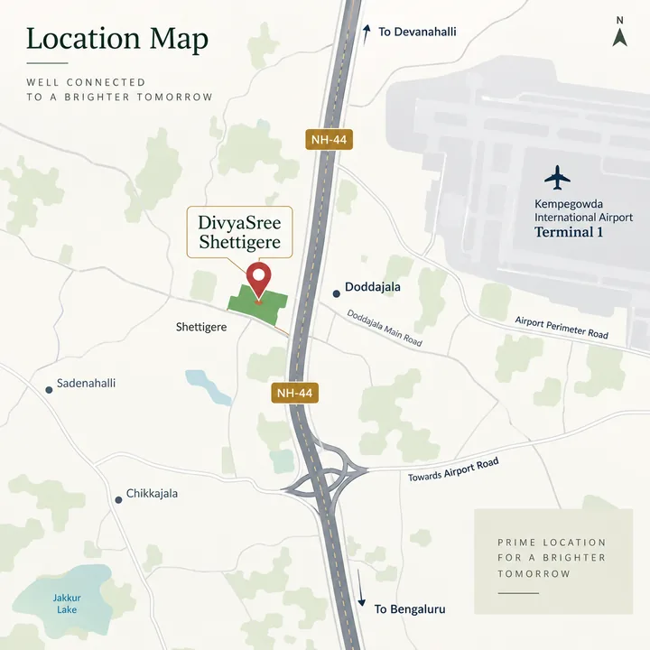
The DivyaSree Shettigere location map
Every distance published on this site is a routed road distance measured from the centre of the boundary the promoter filed, not a straight line across the map.
DivyaSree Shettigere location FAQ
What is the exact address, and is the site in Shettigere village?
The filing lists sixteen survey numbers, most of them parts, marked P: Sy. Nos. 1P, 37/2P, 37/5P, 37/6P, 37/8P, 37/9, 37/11P, 37/12, 37/16P, 37/17P, 37/24P, 37/25P, 37/27P, 39, 40 and 41/1 of Akkalenahalli-Mallenahalli Village, Kasaba Hobli, Devanahalli Taluk, in what the filing calls Bengaluru Rural and the state renamed Bengaluru North district in 2025. Shettigere is the market's label for this cluster and the label we use, but Shettigere village itself lies about 1.6 km west across the taluk line, some 2.7 km away by road. The village name is spelt several ways, including Aklenahalli Mallenahalli on the filing; it is one village.
<!-- sister-link opportunity: prestige-shettigere -->
What are the coordinates and the pin code for the site?
We publish 13.19434, 77.66442, labelled inferred at medium-high confidence: the promoter uploaded a boundary file whose corners are 13.19087, 77.66083 and 13.19782, 77.66800, and our pin is the centre of that roughly 774 m by 776 m box. The box covers about 60 hectares against a 31.25-hectare parcel, a fill of about 52%. Expect the postal code 562157, the registered code of the neighbouring K-RERA project on the same survey numbers; the intake material gives 562110, the Sadahalli code in the same taluk.
Is this under BBMP or BIAAPA, and what khata should I expect?
Neither BBMP nor any Greater Bengaluru Authority corporation. The site tests outside the Bengaluru city boundary by about 8.4 km to the south-west, in Devanahalli Taluk, and plan permission here goes to BIAAPA, the Bengaluru International Airport Area Planning Authority, the body named on the registered neighbour's plan number for the same survey numbers. No building plan has been issued for this project; BIAAPA is where it will be decided. Expect panchayat e-khata and panchayat property tax rather than a city corporation khata: the neighbour's record on the shared survey number carries a Panchayat Raj e-khata and names Anneshwara Gram Panchayat as its water authority.
How far is DivyaSree Shettigere from Kempegowda International Airport?
About 9.7 km by road to Terminal 1. The straight-line figure is 5.1 km, and we name it only to explain the gap: the site lies south of the airfield, so the road goes round by NH-44 and the trumpet interchange. That geometry runs through everything here, because the airfield perimeter closes the north and east while NH-44 crosses only at its interchanges. Several developments within two kilometres of this site in a straight line are eight to twelve kilometres away by road, and for those we publish no figure at all.
Where is the nearest metro station, and is Doddajala a metro station or a railway halt?
Both exist at Doddajala, which is why we separate them every time. The nearest metro station is Doddajala on Namma Metro's Blue Line, about 3.1 km by road, and it is under construction rather than running. No opening date has been announced; the state's stated target for the Hebbal to airport link is late 2027, and that target has moved more than once. Separately, Doddajala railway halt is 4.42 km by road on the Yelahanka to Devanahalli line, and the airport's own rail halt at 7.65 km carries a limited service.
Where are the nearest hospital, school and shops?
This is the uncomfortable half of the location. The nearest mapped hospital is N.R.V. Hospital at 6.37 km by road, with Lakshmi Hospital at 7.17 km, and the nearest credible schools are about 8.2 km away, Katherine Public School and Sterling English Residential School. The nearest department store is Shoppers Stop at the airport, 10.35 km by road, and there is no supermarket within 9 km by road. That is thin provision for 5,474 homes.